By visiting this mythical natural site, you can enjoy an unexpected inner experience, mixing contemplation and movement.

You’re entering a special region that has a unique relationship with time and the elements.

Vue aérienne du village et des falaises d'Etretat

The Alabaster Coast

The Alabaster Coast owes its name to the 140 km of chalk cliffs between the Seine and Somme estuaries. The most picturesque of them are the cliffs of Etretat: they surprise with their verticality and present a wild and somewhat austere beauty.

Attention: walks under the cliffs are forbidden, please refer to the municipal by-law.

Vue sur le Trou à l'Homme, la falaise d'Aval et l'Aiguille à Etretat
La Porte d'Aval et l'Aiguille d'Etretat à marée basse

The Porte d'Aval

The Porte d’Aval (on the left when looking at the sea), a huge flint archway, was carved by the waves beating the end of the Falaise d’Aval. The 51-metre-high needle bears witness to the geological past of the cliffs of Etretat. It has become famous, gained a universal reputation and inspired many painters and writers. Is it hollow and did it shelter the treasure of the Kings of France discovered by Arsène Lupin, as recounted in Maurice Leblanc’s novel, L’aiguille Creuse? You can find out more about this enigma by visiting Le Clos Lupin, the property acquired by the novelist in 1919.

La Manneporte

La Manneporte, even more monumental, is located on the other side of the Porte d’Aval, at the end of Jambourg Beach. Guy de Maupassant claimed that a ship could have passed through it with all sails billowing. 

Un enfant en paddle le long des falaises d'Etretat
Etretat par la mer

Falaise d'Amont

The Falaise d’Amont is the cliff on the other side of the beach, to the right when looking out to sea, and less than a century ago it was called Falaise du Blanc-Trait (White Line Cliff), because of the whiteness of the chalk, visible from the open sea a great distance away.

How can we not pay tribute to Maupassant‘s keen sense of observation, who in “Une vie” compares the Arche d’Amont (arch) to an elephant dipping its trunk in the sea? It’s all there: the trunk, the head and ears, the front and back limbs and even a Maharajah’s palanquin on its back!

La plage d'Etretat et la falaise d'Amont

The Courtine

At the foot of the Manneporte, a vast circular room called Le Petit Port (Little Port) shelters green slopes watered by small springs whose cold waters cascade down: the “Pisseuses”. The Courtine is the thick wall that stands in front of us and pushes out into the sea. An access has been dug there towards Tilleul Beach. 

Roc Vaudieu and the Aiguille de Belval

To the right of the Falaise d’Amont, at the end of the beach, the surprising Aiguille de Belval rises skyward. It seems to be held upright by amazing balance alone: its wave-bitten foot is gradually getting thinner and thinner. Roche de Vaudieu, a refuge for guillemots, looks like a large section of wall standing alone amid the ruins.

L'Aiguille de Belval, située plus en amont du village d'Etretat
Des promeneurs visitent le sommet de la falaise d'Aval

Ancient natural sculptures

Formed underwater several million years ago, the cliffs are made up of deposits of light-coloured calcareous marine organisms and skeletons of siliceous organisms. They then rose up to become these limestone giants streaked with flint.

Particularly hard-wearing, they seem eternal but are nonetheless fragile and constantly changing: wind, tides, rainwater infiltration, freezing and then thawing weaken them: erosion causes regular landslides and the cliff to retreat.

The flint which has fallen down onto the shore takes on its rounded shape in just a few months thanks to the sea, becoming pebbles that protect the cliffs and the town of Etretat, which is built below sea level.

These giants are at the heart of many legends and ancient histories written into the local toponymy: the “trou à l’homme” (cave) saved a sailor’s life, the “ladies’ chamber” became the grave of three innocent young local women.

Balade en kayak près de la falaise d'Etretat

Experience the cliffs

 The cliffs are even more impressive from the sea: the association Voiles et Galets (Sails and Pebbles) invites you to discover the cliffs by kayak, stand-up paddle or sailboat. Starting from Le Havre or Fécamp in season, you can also view them on sea trips.

For the more energetic, the GR21 hiking trail, from Le Havre to Le Tréport, which runs along part of the coastline, takes you through the different valleys of the Alabaster Coast. Geological curiosities peculiar to the Pays de Caux, these cliff openings, these small valleys perched up high or opening onto beaches are exceptional places, intimate and sometimes perilous. Don’t leave the hiking trail and don’t go near the edge, as the cliffs can be unpredictable!

By a municipal decree coupled with a prefectural decree, access to the manhole is prohibited for security reasons.

Warning, these areas are fragile and subject to the whims of the tide.

  • Do not pick up pebbles or leave any litter on the sites.
  • The cliffs are always subject to the risk of rockfalls.
  • Access to the rocky outcrops overlooking the “Trou à l’Homme” is strictly prohibited.
  • Access to the cave and tunnel known as the “Trou à l’Homme” is strictly prohibited.
  • Access to the places known as “La chambre des demoiselles” and “la descente au chaudron” (The Young Ladies’ Room) and the tunnels crossing the cliff tips are strictly prohibited.
  • Access to the full-width beaches, along the entire municipal line, with the exception of the area adjacent to the promenade dike, is strictly prohibited.
  • Pedestrians are strictly prohibited on the high plateaus of the upstream and downstream cliffs, with a safety distance of at least 5 meters for both sites from the break in the slope.
  • The municipality disclaims all liability in the event of an accident occurring as a result of non-compliance with the requirements and prohibitions of this decree, as well as in the event of crossing the fence, any fence, or any other device intended to prevent access to the edges or bases of cliffs located within its territory.
  • Only local authority technical services, experts commissioned by the Administration, and safety and emergency services are authorized to walk along the top and bottom of cliffs to carry out their assigned tasks, equipped with appropriate personal protective equipment.
  • In accordance with Article R.610-5 of the Criminal Code, violation of the prohibitions and obligations set out in this decree is punishable by the fine provided for Class 2 offenses. Fees will be applied by the SDIS 76, according to the rates applicable to non-emergency interventions (deliberation of 04/12/2024).
  • For your safety, please read the ORDINANCE REGULATING WALKING ON THE COASTAL BOUNDARIES OF THE MUNICIPALITY OF ETRETAT BETWEEN THE BOUNDARIES OF THE MUNICIPALITIES OF LE TILLEUL AND BENOUVILLE.
  • Read the ORDINANCE REGULATING WILD CAMPING, BIVOUACING, CARAVANNING, AND CAMPFIRES IN THE MUNICIPALITY OF ETRETAT.

Rare fauna and flora to enjoy

The local flora has adapted to this confrontation between the immensity of the sea and the gigantic cliffs: specific vegetation has developed on this coastal environment, such as the sea cabbage with its thick, fat leaves, resistant to wind and salt.

Protected animal species also live on the site: seabirds, insects and amphibians. The cliffs and their cavities provide shelter for herring gulls and seagulls. Take your time: observe the animal life around you! 

You can find out more about these protected species during guided tours offered by Naterra.

Balade naturaliste avec Natterra sur les falaises d'Etretat
Etretat le Perrey

A great site to preserve

The Grand Site Falaises d’Étretat – Côte d’Albâtre extends over 13 municipalities (Bénouville, Bordeaux-Saint-Clair, Criquebeuf-en-Caux, Étretat, Fécamp, Froberville, La Poterie-Cap-d’Antifer, Les Loges , Le Tilleul, Saint-Jouin-Bruneval, Saint-Léonard, Vattetot-sur-Mer, Yport) spread over the two intermunicipalities which are the urban community of Fécamp Caux Littoral and the urban community of Le Havre Seine Métropole.

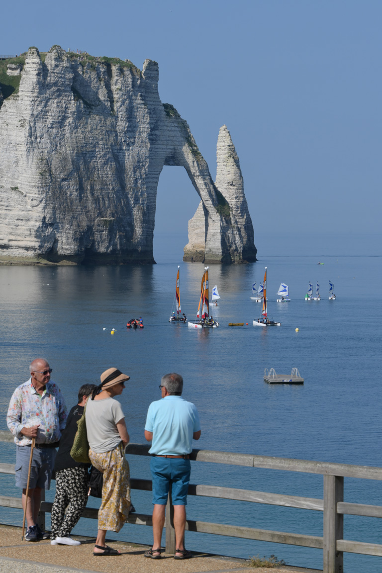
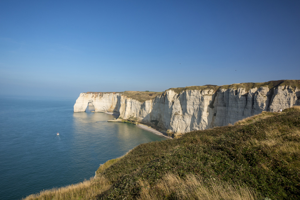
This territory is in the process of being labeled “Grand Site de France“, a distinction which aims to preserve the landscape. Indeed, the cliffs of the Alabaster coast may delight the eyes of walkers, they are threatened. To preserve them and promote sustainable tourism, the Department of Seine-Maritime supports the 13 municipalities and the two intermunicipalities in an approach aimed at facilitating the reception of visitors while safeguarding these remarkable landscapes. Each visitor can participate in the protection of this territory by simple gestures.

Respect

In order to preserve the cliffs, it is imperative to leave as few traces as possible of its passage. For example, by not throwing your rubbish in nature but by depositing it in the bins provided for this purpose. However, it can happen that in periods of high attendance, the latter find themselves full. In this case, it is advisable to take a bag to keep your waste until the next basket.

In order to preserve the territory and in particular the coastline, it is also important to stay on the marked paths and not to pick up pebbles on the beach, the latter serving as a natural rampart against storms.

Falaises Etretat

Infos pratiques

Le Havre Etretat Tourisme - Place Maurice Guillard, 76790 Étretat - 02 35 27 05 21

You may also like...

Musée du patrimoine d'Étretat

Land-based activities

Musée du patrimoine d'Étretat

ETRETAT

Les Jardins d'Étretat

Land-based activities

Les Jardins d'Étretat

ETRETAT

Le Clos Lupin - Maison Maurice Leblanc

Land-based activities

Le Clos Lupin - Maison Maurice Leblanc

ETRETAT